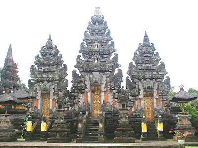
 This hindu temple is located at Senduro, Lumajang Regency, on slope of Gunung Semeru, the highest peak in Java. This temple was finished in 1992, but the idea started more than 20 years before the legal permission granted to build this shrine. Before the temple erected, local people prayed at sanggar pamujon, small shrine located almost every corner of the village. The idea appeared after Balinese Hindu held nuur tirta (praying for holy water) at Watu Kelosot spring at slope of Semeru for Karya Ekadasa Rudra, in 1963 and later also held in 1979 that was also followed with Majauman ritual. Since then, nuur tirta and pura kahyangan jagat in bali held big scale of ritual there.
The temple location nearby Gunung Semeru is not a reckless decision. There is a very strong concept that backgrounds related with Hindu literature sources. It was written that when Jawa Island was still unstable, Batara Guru ordered gods to cut the summit of Gunung Mahameru from Bharatawarsa (India) to Jawa. Then gods cut the Mahameru and flied it ti Jawa and dropped it on the western part of Jawa, that made Jawa shaking. Eastern part lifted and western part was sunk. The mount cut then carried to the eastern part. On the way from east to west of Java, there are crumbs of the mountain fell, and later the crumbs grow as Gunung Katong (Gunung Lawu 3.265m), Gunung Wilis (2.269 m), Gunung Kampud (Gunung Kelud, 1.713 m), Gunung Kawi (2.631 m), Gunung Arjuna (3.339 m), Gunung Kemukus (3.156 m). And the real cut of the mountain became Gunung Semeru (3.876 m), the highest peak in Java located at Tengger Mountains, and connected to Gunung Bromo. From that moment on, Jawa is stable, no more shaking and moaning. That is where Pura Mandara Guru Semeru Agung stands. That story was written in Tantupagelaran in Central Javanese language.
This shows that Hindu Siva districution in India to Indonesia was centered in Java/ Jawa. In Hindu Siva that influenced Indonesia, including Bali, the highest god is Siva. Siva lived on highest mountain, means on Himalaya in India or Gunung Semeru in Indonesia. IN Purana text, India, included in Upaweda holy book, said that the single and almighty God resided on peak of Mahameru, known as Kailasa Mountain or HImawan Mountain that had eternal snow.
The mountain peak was known as great padma center, Siva, known as Parwataraja Dewa, and delivered his teachings via his Sakti, Parwati, the goddess of mountain. His teachings are written in conversations form between The Siva with Parwati and then recorded in various Yamala, Damara, Siwasutra, or Tantra holy book. Books elaborate about yoga teachings gave guidance to sandhaka, one that is discipline and persistent creating oneself as mean of basic yoga practice, mountain peak as sahasrara padma, means the human sinciput. So the mountain peak is just like human head, an important part that should be maintained its purity.
Sivaistic belief gave important honor to mountain. Where there is a highest land in a region, that is where the world centered (Madyanikang bhuwana) and also the upstream of a region. That is where God, the Holy Siva, is worshipped. No wonder is sacred shrine is established on mountain, whether on peak, slope or foot of mountain, as there were spiritually the most sacred region.
If it is not on mountain, temple is oriented to mountain direction. The shrine is shaped like cone, resembles mountain, in shape of temple in Java or padmasana or meru just like in Bali. Or else in lingga shape. From this philosophy, mountain is also called as Lingga acala, or not-move lingga that is not created by human. In old Javanese language, acala means mountain or cliff. Hindu teaches human to be oriented to something eternal, something not-moving as goal. In consequence, beside mountain, Hindu also worship sun as the eternal energy source.
Basic universal vision backgrounds temple to build on Gunung Semeru where Indonesia Hindu worship Hyang Siva Pasupati. Semeru peak became Gunung Agung(same meaning as Mahameru) where Hyang Putranjaya or Mahadewa resideds. The crumbs became Gunung Batur (1717 m) the palace of Dewi Danuh (Wisnu) and Gunung Lempuyangan as the palace of Hyang Gnijaya (Iswara). Since then, Bali was stable and the three mountains are regarded as important beside GUnung Watukaru (2276 m), Puncah Mangu, Penulisan (1475 m), Andakasa, Uluwatu and Goa Lawah. Gunung Agung is regarded as the center of Bali, as it is the highest peak in Bali. Therefore, until today, if there is a ceremony in Pura Agung Besakih or other Sad Kahyangan temples in Bali, Balinese do ritual nuur tirta to Semeru first. If a ritual held at Pura Semeru, a matur piuning to Pusa Sad Kahyangan in Bali is proceeded, including Gunung Rinjani in Lombok (3726m ).
From mountain, that is overgrown by trees, water flows fertile soil, earth. Before that water was accommodated in a lake, and flows through rivers and creeks. After used by human, water is channeled to ocean and sun heat vaporize the water to cloud and then falls as rain. The rain is absorbed by mountain with its trees, and accommodated in lake, absorbed to earth and becomes springs, flowing and flowing. so and so, cycling over and over.
That is the reason why mountain is positioned as upstream in Hindi cosmology, lake as the midstream and ocean as the downstream. They creates universal cycle flow. From mountain as upstream where the bless flow to all creatures. When there is Tawur AGung ritual at Pura Besakih, Pura Gunung Agung or Pura Mandara Giri Semeru held, the offering will be flowed to rivers, farms, sawah, trench, and so on. The decision highest mountain as the world axis is based on broad and depth insight, not only spiritually, but also cosmologically, geographically, sociologically, with strong ecological awareness.
 Ranu Pane covers 1 hectares and Ranu regule covers (0.75 hectares) are two lakes located at Bromo Tengger Semeru National Park. To reach both lakes, there are two routes, Lumajang route via Senduro (50 km) and Malang Route via Tumpang (53 km). Both lakes located on 2200 meters asl and with nice scenery.
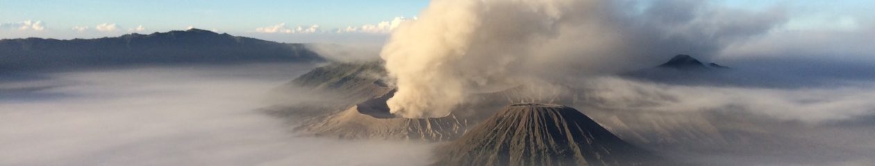
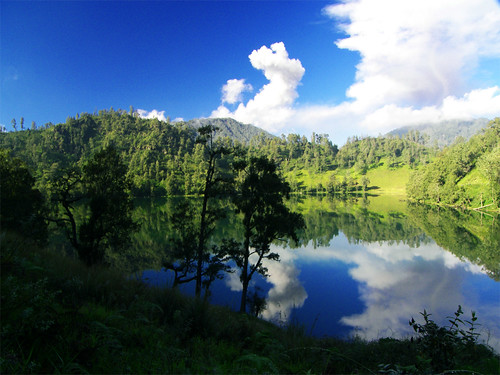 Ranu Kumbolo is located on slope of the highest peak of java, Gunung Semeru or Mahameru. The crated of Semeru is an active crater that always expels volcanic material, its name is Kawah Konggring Saloko.
 The trip to Ranu Kumbolo takes a very good stamina, and sufficient logistic, and should prepare everything carefully. The trek to Ranu Kumbolo will pass very nice scenery, but trekkers should be alert. From Ranu pane there is 5 km of slope with Edelweiss grows everywhere, and trekkers will pass Watu Rejeng, where there is a very beautiful steep rock. The valley and hills overgrown with pines look amazing from the track, sometimes smoke from Semeru peak can be seen. The trek from Ranu Pane to Ranu Kumbolo usually takes 5 to 6 hours.
 Train tour is available at Garahan, at Banyuwangi to enjoy nice scenery of Gunung Gumitir. Gunung Gumitir is overgrown with coffee, cocoa and pine. The route is from Kalibaru Station to Garahan Station passing Mrawan Station.
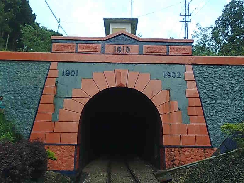 In Garahan Station, yesteryear and humble tools, such as: Telegraph, to send and receive long distance message, telephone, Morse to send and receive news inter stations, bell that is sounded when train is arriving. An there is a bell to sign train, danger, shift over :
 Although there is no record, Batik Pekalongan had been practicing in the region in 1800s. According to local industry, there is a motive that was created in 1802, such as motive of small tree. It is estimated that there was a significant development after big war in 1825-1830 in Mataram period, known as Diponegoro war or Java war. With the war, many of the royal family moved with their companies that spread to East and West Java. That was when they started to work on batik in their new place.
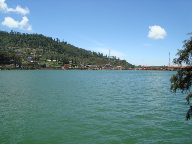 Benteng Van der Wijck is located in Kebumen, only 300 meters from mainroad of Yogyakarta-Kebumen. The fortress is dominated with red color. A mini train will transport visitors from main gate to this historical site.