Pura Selaka Giri Alas Purwo, Banyuwangi, East Java, Indonesia

When Majapahit Kingdom fell down in the 14th century, Majapahit leaders said ” Majapahit might be destroyed, but wait until 500 years again, and the descendants will rise and ask for the former Majapahit territory”.

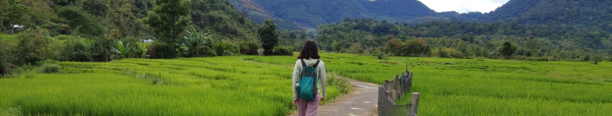
Alas Purwo is a lush forest, and a National Park and the Hindu temple, Pura Selaka Giri Alas Purwo is located one hour from the national park gate. On the left and right side of the road, there are teak trees and only few people live nearby. Hindu people in Tegaldlimo, Banyuwangi go to the temple by riding a traditional transport called grandong, resembles to truck only the machine used is gen-set.

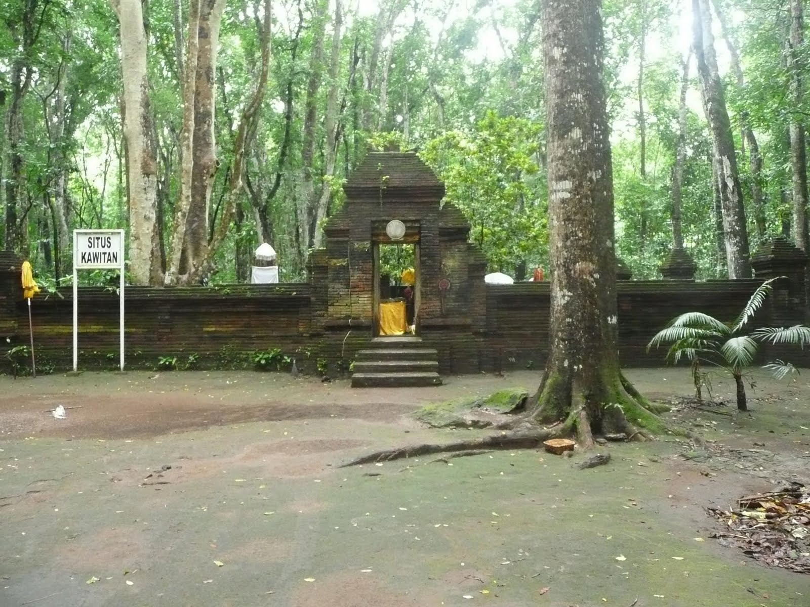
Giri Selaka Temple is located in the middle of jungle, and about 3 km from beach, and no inhabitants there. The national park provides humble inn located one km from the temple. But Hindu people prefer staying at the temple area. The temple covers 2 hectares, given by forestry minister, the authority of national park.

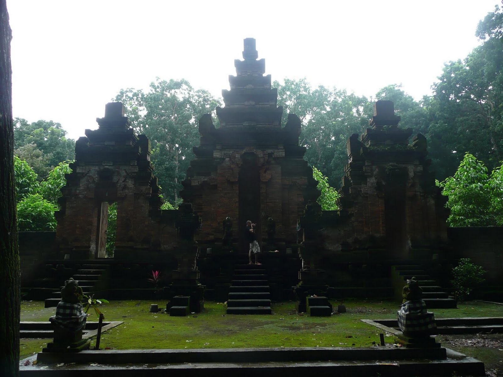
According to elder of HIndu Tegaldlimo, Pemangku Ali Wahono, Pura Giri Selaka was found coincidentally by local hindu in 1967. People in Tegaldlimo, in that very time, was cultivating land around the national park, and a mound was found on where the current location of the temple. They would like to flatted the mound for agriculture but they discovered big blocks of bricks resembled to a small gate. Local people brought the blocks home and used it as house hold such as for fireplace. People that too the bricks got sick and they returned the bricks to its former place. It said that the bricks was the mark of Mpu Baradah site, though there is no record or inscription found about this. Other opinion said that it was Rsi Markandiya site before departing to Bali. Local people also believe that the power and the sacred of this site so they protect it. Archaeological service made effort this site as heritage. And on the other side, Hindu people in Mariyan, believe that that site was their ancestor’s. To avoid conflict, then Hindus built temple 65 meters from that site. And until today the site is remain the same and becomes shrine not only for Hindus. Since 1972, gradually,  Forestry and Plantation Dept policy to take back the region of Mariyan, and did reforestation with teak trees. And Alas Purwo was isolated again in the forest. But Forestry Dept allow people to enter the forest to pray or meditate.

Gunung Penanggungan, Mojokerto, East Java, Indonesia

Gunung Penanggungan is also called as the miniature of Mt Semeru as the summit is a barren. Its height is 1653 m asl, and the summit consists of rock and rarely overgrown by trees, that from far away it looks like a bald head. At night the temperature at the peak can reach to 10-15 deg while at day around 15 to 25 deg. There is a cave, Botol Cave, that was recently found located on Mt Penanggungan that can accomodate 15 people. The cave is located 500 m from the summit on the west direction. There are 2 entrances of the cave. One entrance from upper side. The cave room is in L shape. The entrance faces  north and south and 2 meters depth. This cave is used as shelter for climbers from wind, rain and cold temperature.

From the foot of Mt penanggungan there are several protected forest with trees such as jempurit, kluwak, ingas, kemiri, dawung, bendo, wilingo and jabon. Under the trees grow spices such as turmeric, laos, ginger, and smal flowers. The lush trees cause the area humid, sunlight does not shower the earth surface entirely. The slope is overgrown with Calliandra calothyrsus, Resap, Pundung and Sono. Red Calliandra dominates the slope, though it grows stunted in the middle of grass. On the top, there are only gebutan roots grow through hard rock of Mt Penanggungan.

Mt Penanggungan climbing route is flat, awry, hilly and has ravines. On the foot of the mountain, the track is flat for 2 km and then followed by 30 to 40 deg slope. On the middle of the route, the slope is very steep, 40 to 50 deg for 1 km. Closer to the summit, there are ravines of 50 60 deg, and rocky track fro 2 km. Then followed by avery steep, slippery, and slope track  of 60-80 deg for 1.5 km. At the summit, there are rocks and there is a 4 ha cavity, could be a inactive crater. The cavity can be used as camping site and suitable to enjoy beautiful night. To get to the summit of Mt Penanggungan, there are 4 climbing routes, via Trawas, Jolotundo, Ngoro and Pandaan. If climbers climb via Jolotundo and Ngoro, along the track will pass historical temples.

Trawas Climbing Route
To get to Trawas, from Surabaya or Malang, to Pandaan and then take minibus to Trawas. From Trawas, Mojokerto to Rondokuning village (6 km) by 2 wheels or 4 wheels vehicle. From Rondokuning passing footpath natural forest for 3 hours and along the track there are scenery among calliandra trees, and summit of Mt Bekel, the child of Mt Penanggungan looks very spooky. Houses, factories, sawah can be seen down the mountain.

Jolotundo Route

To reach to Jolotundo from Trawas, we should take another minibus for 9 km. Jolotindo village is one of villages located nearby Mt Penanggungan. This route takes 3 hours to top through jungle and 40 deg slope through narrow path. On the left and right side there are big tress, and be careful here as sometimes will make you lost. After hiking for an hour, there are lush calliandra trees and the track is steep. 30 minutes later, passing Batu talang, a 7 km long rock from the neck of Mt Penanggungan to Jolotundo village and Balekambang village.  From Batu Talang, then proceed deeper to calliandra forest, after 300 meters, you will arrive at Candi Putri remain from Airlangga period in non-intact condition with size of 74×74 m. Candi Putri is surrounded by lush  calliandra forrest. 200 meters from Candi putri, located Candi Pure, a temple made of andesit blocks.  150 meters from Candi Pure lies Candi Gentong, where there is located a table and a barrel made of andesit blocks..  Gentong (barrel)  is 40 cm diamete on its lip and 90 cm on its middle and 15 cm thick. And the table is 175 smx 100 cm and 125 cm high. 50 meters from Candi Gentong located Candi Shinto. This temple is a bad condition with size of 6mx 6 mx 3m and located in area of Seloliman. After passing 300 meters through forest , there are another temple Candi Carik and Candi Lurah, and the the summit of Mt Penanggungan. 

Ngoro Route

To reach Ngoro can be via Pandaan or Mojokerto. The village to start climbing is Genting village, where climbers should pass through forest and thenpassing Candi Wayang and after 2 km there is a very steep track of 70-80 deg. This route is more difficult than via Jolotundo.

Ranu at Gunung Lamongan, East Java, Indonesia

To see nice scenery at Lumajang, we do not need to pass winding road. The beautiful scenery of lakes and Semeru and Lamongan can be seen easily. Different than Lake Tamblingan and Bedugul in Tabanan Bali that are located on slope. Ranu Klakah and Ranu Pakis are located only 1 km from Klakah-Lumajang main highway, notable on northern of Lumajang at Tegalrandu village. The location is not far from Klakah district and make these lake accessible by motorbike taxi and horse cart or car.

Ranu Klakah is located on 900 m asl, and covering 22 hectares and 28 meters depth with Mt lamongan as the background. The temperature is cold and fresh.The lake looks like having blue water. This lake is one of triangle lake, Ranu Klakah, Ranu Pakis and Ranu Bedali. Each of the lake is connected with road. And even in Ranu Pakis Mt Semeru is visible beautifully.

Ranu Pakis is only 10 minutes from Ranu Klakah , located 600 meters asl and covering 50 hectares and 26 meters depth. Other activities with family is available here, such as fishing, boating, and children game.

Gunung Lamongan, East Java, Indonesia

Mt lamongan is located between 2 complexes of volcano, Tengger complex on the west and Iyang complex on the east. Mt Lamongan (1668 meters) is categorized as one of 21 volcano in Indonesia in Class A, that at least erupts magmatic eruption one time since 1600. This volcano is recorded to explode in 1799. And even until 1889, this volcano held record as volcano that most frequently explode. Lamongan was higly active volcano, but the record was taken over by Mt Semeru. Last eruption was on 2012.

This mountain is unique, different than other mountain in Java. If you climb to the top, there is a very nice scenery. From distance Mt Semeru looks amazing and tectonic lake on foot of Mt. Lamongan is also visible.

In geology and volcanology, tectonic lake is known as maar. Maar was created for volcanic explosion with round shape and steep wall. Maar was formed by freatic and freato magmatic explosion. In 1907, until today there are 10 maar on earth. But in the prehistoric period, there were many maar created. The biggest and most amazing maar was created at Pematang Bata, in 1933. 2 maar with 1 km and 2 km diameter. Maar is a very rare phenomenon. Until today, Volcanology directorate has not detected maar activity of Mt Lamongan.

Climbing Mt Lamongan started from Klakah, and before starting the trip, usually climbers rest at papringan villagge where there is  spring for water supply. From Klakah to Papringan only take one hour walk. From Papringan, climbers can meet Mbah Citro, and it takes one hour to get to his place. And climbing can be started at night. Climbing can be started at 22.00, around 23.00 you will arrive at Watu Gede with flat track. At Watugede, climbers can rest here for 1 or 2 hours. At 01.00, the climbing can be proceeded. After passing steep rocky track, then fern forest is the next route. Usually climbers will arive at 09.00 at the top and see the sunrise and beauty of Mt Raung, Argopuro, Semeru and Tengger complex.

Volcano Explosion Level

LEVEL 0 (Hawaiian Level)
Hawaiian explosion is type of volcano explosion which lava from source is relatively in shallow explosion, low level and called so as the characteristic resembles Hawaiian volcano.Usually it is an effusive explosion, magma basaltic with low viscosity, in low gas contents and high temperature on hole. With eject-volume less than 10.000 m3 and plume less than 100 meters. Volcano in this category: Mt Kilauea Explosion in Pacific and Mt Piton de la Fournaise.

LEVEL 1 (Strombolian Level)
This type of explosion is relatively low level explosion, and named after volcano in Italy and the explosion constitutes of ejecting lava, lapili and lava bomb to hundred meters high. They have medium and small volume and sporadic sound. Volume of ejects more than 10.000 m3 and plume 100 – 1000 m. Explosion in this category: Stromboli Volcano in Italya explosion in April 2009 and Mount Nyiragongo explosion in Congo in 1977 dan 2002.

LEVEL 2 (Volcanian Level)
This term was used initially by Giuseppe Mercalli, when he overlooked explosion at Volcano Island in 1880-1890. The description about the explosion type is used around the world, marked by thick ash cloud with gas the explodes from crater and rises to the sky above its summit. Eject volume more than 1.000.000 m3 and plume 1-5 km. Explosions in this category: Mt Galeran (Columbia) explosion on August 25th 2010 and the worst in 1993. Mt Sinabung in Indonesia last eruption in September 2010.

LEVEL 3.(Pelean Level)
Pelean explosion has condensed magma, rhyolitic or andesit, they are involved and similar to volcanian. Most important in a Pelean explosion is erosion of hot volcanic ash, pyroclastic stream and forming a lava dome. Short-circuit of ash or forming of pumice cone can also be seen. Volume eject more than 10.000.000 m3 and plume 3-15 km. Explosion in this category: Mount Nevado del Ruiz explosion in Kolombia. And Mount Soufrière Hills at Monsteratt ,Karibia.

LEVEL 4
This level is similar to Level 3 and Level 5 and ejects volume more than 0.1 km3 and plume 10-25 km. Explosion in this category: Mt Pelée in Martinique and huge eruption was in 1902. Mt Eyjafjallajökull in Iceland, last eruption was in May 2010.

LEVEL 5 (PLINIAN EXPLOSION)
Plinian explosion is also known as Vesuvian exxplosion, and volcano explosion is marked with similarity to Mt Vesuvius date back 79 (as written by young Plinius that killed his uncle Pliny the Elder). Palinian explosion characteristic is gas column and volcanic ash soars high to stratosphere, the highest atmosphere layer. The main characteristic is expelling pumice and very strong continues gas explosion. Volume ejecta more than 1 km3 and plume 20-35 km. Explosion in this category is Mt Vesuvius explosion in Italy in 1944 and huge eruption in 79 BC. Mt St Helens eruption in USA in 1980 that killed 81 people.

LEVEL 6
This level is similar to Level 5 and Level 7. Volume eject more than 10 km3 and plume more than 30 km. Volcano in this category is in 1883 that yielded tsunami. Mt Pinatubo in the Phillipines that killed 847 in 1991.

LEVEL 7 (Ultra Plinian Level)
According to Volcanic Explosivity Index Smithsonian Institution, VEI 6 to 7 are classified as Ultra Plinian. They are defined by ash of more than 25 or 16 miles high and volume of explosion 10 km3 from 1000 km3. Example in this category are Mt Tambora (Indonesia) explosion in 1815. The mountain was gone after the explosion.

LEVEL 8 ( Super Volcanic Level)
From its name one can imagine how huge this explosion. Explosions in this category are: supervolcano Yellowstone, Creek lava that exploded 640.000 years ago, and expelled 240 km cubic (1.000 km3) of stone and ash to the sky and this volcano is still active. Toba explosion around 67.500 to 75.500 years ago. Toba explosion was the last of seris of 3 explosions that created caldera from volcano, the previous caldera was created 7000.000 and 840.000 years ago. The last explosion had explosivity index of volcanic 8 or called as mega-colosal and could be the biggest volcano explosion in the last 25 million years. And quake in 2004 that struck Sumatera and changed earth shape as detected by GRACE satellite. The quake activity can initiate magmatic activity of Toba.

Dieng Double Sunrise Phenomenon

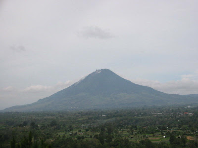
Dieng Plateau, a plateau located in Wonosobo, Central Java, Indonesia. In this plateau visitors can enjoy two times sunrise in the same morning, silver and golden sunrise. For this double sunrise tour, you should depart early morning. You can stay overnight at Wonosobo or Dieng Plateau for this.

If you stay overnight in Wonosobo, whether in the city area or outside the city,  it is possible to depart at 04.45 from hotel head to Setieng view point which is located 1700 m asl. From here you can enjoy a very nice and tranquil scenery early in the morning of village, hills, river and agriculture land. Around 6 o’clock the golden sunrise will rise after beautiful color of horizon. Mt Merapi is visible from here. The best time to see sunrise in Dieng Plateau is around May to August, when dry season rules.

After the golden sunrise, then proceed to Dieng Plateau, where oldest Hindu temples in Java located. This plateau is 2100 m asl with cold temperature. The silver sunrise appears from behind a hill. The silver light showers the plateau that sometimes misty and yield a mysterious nuance.

If you stay overnight at Dieng Plateau you can trek to Gunung  Sikunir (2350) to see the the golden sunrise.

Dieng Double Sunrise Tour 3 Days/2Nights
Overland Tour with Dieng Double Sunrise

Gunung Panderman, Batu, East Java, Indonesia

Mount Panderman is one of Batu City icons. This mountain is visible from every corner of Batu City and becomes a beautiful background. The summit can be seen clearly from beneath and it takes good stamina as the road to the summit is tiring. If coincidentally  you are at Batu city square, this 2045 meters asl will be like a backdrop.

To climb Mt Panderman, there are two routes. The first route is the most common route via Toyomerto village, Pesanggrahan. From Pesanggrahan you will pass Latar Ombo, where usually climbers can supply water, or camp, and the to Watu Gede where there are numerous huge rocks (watu dege in Javanese). The second route is very rare known and this is not a common route and there are no facilities such as parking area and water supply as not designed for climbing base.  The second route is a shortcut to the summit and for Batu climbers, this is their fave route to Mt Panderman. This rote is called as Curah Banteng route, a challenging route that few track is 90 deg awry and can only be reached by climbing method.

The scenery along the second route is beautiful only it is more dangerous than the second route. Climbers will pass the edge of Curah Banteng and if lucky climbers can see edelweiss along the route. This route starts from Kusuma Agro Wisata Hotel and then to the base of climbers. It takes round 2 hours to get to the summit.

Mount Panderman name derives from a Dutch man Van der Man, who admired this mountain.